Image distributed by the developer.
Third in a series, after “We Know Who You Are Working For” and “Reparations: ‘The Preferential Rental Option for the Displaced'”
A developer has filed an application with the City of Newburgh to build a 172-unit market-rate residential and office complex on ten acres of waterfront ground south of Washington Street. The ground was cleared by federal urban renewal action between 1964 and 1972, when the East End neighborhood — disproportionately Black, mostly low-income, mostly tenants in buildings owned by small landlords — was demolished and its residents displaced. The cleared land has been held empty for sixty years. The developer’s proposal, now under review at thirteen separate municipal, county, state, and federal agencies, is, to the best of my knowledge, the first attempt in six decades to redeem what the framework cleared on this particular lot. The form proposed is the subject of this essay.
The Form
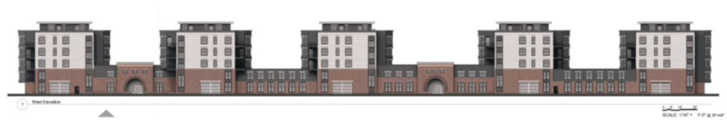
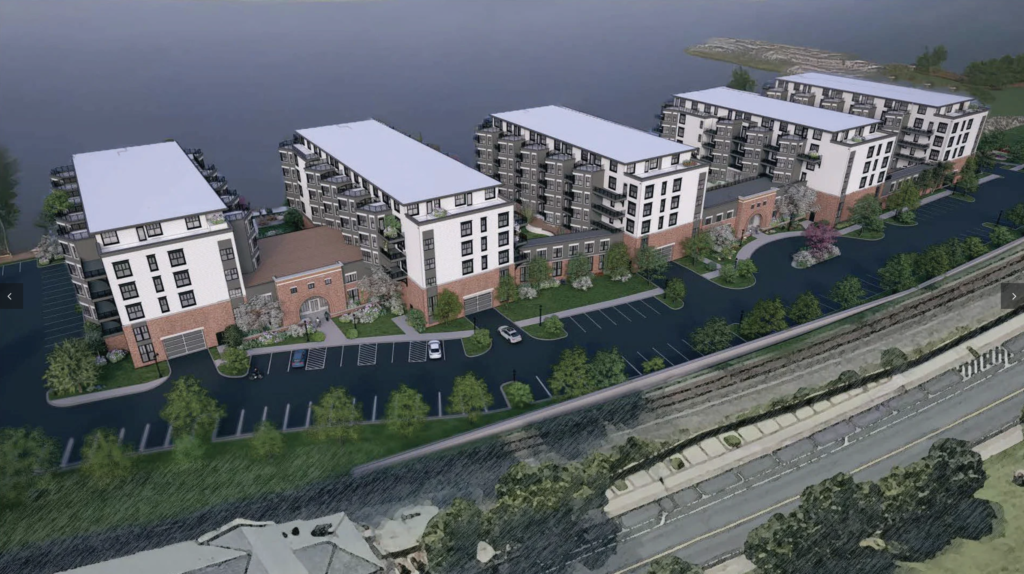
Begin with the visuals.1 CAD renderings circulate with the application: five gray masses standing above a pale platform, the Hudson River silver behind them, a thin path along the water’s edge, dusk lighting designed to soften the proportions. The masses are presented as five separate buildings. They are not five buildings. They are one structure expressed as five masses on a continuous podium, and the podium is the building. Everything else is decoration on what the podium does.
The podium is a raised platform covering most of the ten-acre parcel. It holds a 189-space enclosed parking garage on what would otherwise be the ground floor, surface parking for 281 additional vehicles, and the residential and office program lifted above. Total parking: 470 spaces. Residential units: 172. Commercial space: 25,000 square feet.2 Parking ratio: 2.73 spaces per unit before commercial demand is counted. The civic level of the site is given over almost entirely to vehicle storage. The developer’s own response letter describes the access regime in plain language: “Parking areas specifically designated for the uses on site are controlled by armed security barriers.”3 Residents enter the platform through the garage. Pedestrians do not enter the platform at all.
What the rendering presents as a waterfront mixed-use development is, in section, a fortified compound. The garage at base. The platform above the garage. The five residential and office masses above the platform. The amenity decks — community garden, dog park, pool, gym — interior to the masses, accessible only to residents.4 A planted hedge running along the river edge, screening the platform from the riverwalk and the riverwalk from the platform. A twelve-foot strip of public access along the water, reached not through the development but past it,5 bordered on its inland side by boxwood and skip laurel and bayberry that perform in landscape what the architecture performs in section.6
The form is quite a bit older than its rationalizations. A fourteenth-century castle surrounded by a moat solved the same spatial problem the same way: a barrier of inhospitable ground separates the residents from those who would approach, residents enter through a controlled passage, the habitable interior sits elevated above the surrounding earth. The gated community of late twentieth-century America used the same diagram in suburban form, with the moat replaced by a perimeter wall and a guardhouse at the entrance. The proposal at the Newburgh waterfront uses the same diagram again. Replace the moat with a parking field, the drawbridge with an armed security barrier, the keep with a residential podium, and the form arrives in 2026 essentially unchanged from its medieval ancestor.
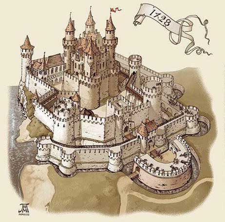
Castle, fifteenth century. Note the curtain wall rising directly from the platform’s edge, the platform itself rising from the surrounding ground, the platform’s masonry rendered distinct from the curtain wall’s masonry, and the height differential between platform and ground.

The developer’s own renderings confirm the fortification reading in the developer’s own architectural vocabulary.7 The entry to the platform is composed as a brick arch with a keystone, set into a stone-faced base, accessed through a pedestrian-scaled gatehouse that is unmistakably the architectural memory of a castle gate. There is no other way to read the rendering. The arch is rendered against the side of the platform; smaller windows above the keystone suggest a porter’s lodge; pedestrians pass beneath the arch into what the next image reveals to be a parking court. The masonry portal, the keystone, and the small upper windows all serve to dignify the act of entering a parking field. The dignification is the form’s most candid statement of what it values. The architectural lineage the prior paragraph traced abstractly — castle, gated community, 2 Washington — is what the developer’s own design vocabulary is doing on purpose. Any competent architect knows exactly what the form is and has rendered it accordingly, presumably at the request of the developers.
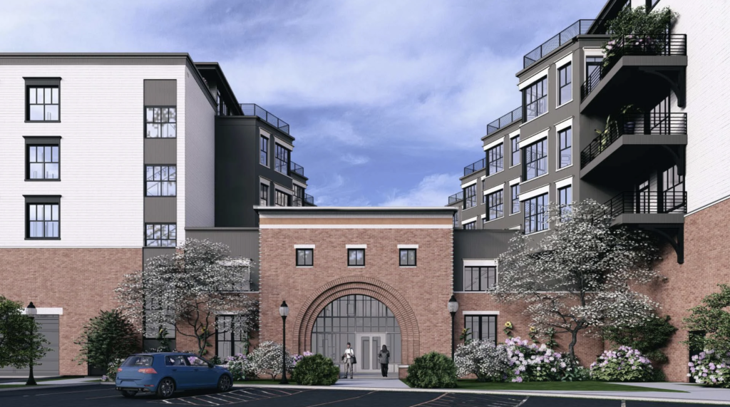
The developer’s own renderings confirm the fortification reading in the developer’s own architectural vocabulary. The entry to the platform is composed as a brick arch with a keystone, set into a stone-faced base, accessed through a pedestrian-scaled gatehouse that is unmistakably the architectural memory of a castle gate. Image from the developer’s own website. Image from the developer’s own website.
The organization of social space inside the platform is the organization of a suburban condominium development. The supporter letters and the developer’s own FAQ describe the project in urbanist vocabulary — walkable, mixed use, density, infrastructure-supported, transit-adjacent — but the spatial logic the renderings disclose is not. The amenities are interior to the platform, behind the gate, programmed for a paying clientele. The swimming pool, the dog park, the community garden, the paved amenity courts between the masses, the rooftop terraces: all sealed against the surrounding city, accessible only to residents. This is the suburban condominium template, in which the building manages a private interior environment, face inward, and the surrounding territory is a backdrop. Compare it to actual urban density, where the amenities are public and external, facing outward — the city itself is the amenity, the street is the social space, the park is shared with strangers. The 2 Washington plan does not extend the city’s social fabric onto the parcel. The developers claim that they are giving the city density, something that the city wants. But it is not just about density: it is also about FLOW. A project that faces inward instead of outward is not creating density, it is creating a hole. It withdraws a private interior fabric onto the parcel and treats Newburgh as the view from the windows. The parking ratio confirms the typology. Even on the developer’s own count — 189 covered project spaces for 172 units, before any allocation of the 250 surface spaces designated for continued public use — the project’s parking is approximately one space per unit. Genuinely walkable urban projects in transit-supportive locations have parking ratios well below one, often as low as half a space per unit, because the urbanist proposition is that residents do not need a private car for every household. One space per unit is suburban. The form does not believe its own urbanist marketing. It is designed for residents who drive everywhere and park at home, and it offers them a building that resembles, in every relevant typological respect, the developer’s own existing suburban product. The Residences at West Hills Country Club, advertised on the developer’s website as a first-class luxury apartment community with spacious units and private balconies overlooking the Wallkill River and a championship golf course, is the same building.8 2 Washington is West Hills with a Hudson view instead of a golf course view. The waterfront site is a venue change, not a typological change.
But let’s take the developer’s claim about density itself at face value.
Density, … or sight lines?
Begin with the arithmetic. One hundred seventy-two units on ten acres is seventeen units to the acre at five stories. That number does not describe what five-story construction is capable of. A five-story building of comparable type, designed as urbanism rather than as a suburban template, routinely delivers between forty and one hundred fifteen units to the acre. The lower end is more than double what is being proposed at 2 Washington. The upper end is nearly seven times. The height the developer has chosen is not the constraint on the unit count.
The site plan is the constraint on the unit count. And the site plan is governed by sight lines.
That is likely the determinative constraint on the unit density: a clear sightline from every rear balcony to the river. Once that is the governing geometry, the rest of the design follows by necessity. Five parallel slabs perpendicular to the water — the only orientation that gives every unit a view. Narrow slabs, because a wide slab blocks the units behind it. Wide gaps between slabs, because adjacent buildings would obstruct each other. Five stories, because additional height would require additional setback to preserve the angle. And seventeen units per acre, because that is what is left over once the view-preservation geometry has consumed the parcel. Density is not a target in this proposal. Density is the residual.
The developer is not building housing on this waterfront. The developer is building one hundred and seventy-two private viewing platforms, and the rest of the ten acres exists to keep the platforms unobstructed. The waterfront ribbon — a thin path along the bottom edge, without depth or programming — is the maximum public sight line access that is compatible with the private one. A real esplanade would bring the public close enough to the buildings to compromise the units. The public is permitted to traverse the edge of the site. It is not permitted to occupy it.
This is the form of the proposal. It is a private compound organized around a sightline, sited on a public edge, sold to the city as housing. Density is the word the developer uses to describe what the form leaves behind.
Ten acres at seventeen units to the acre at five stories means that the building footprint is occupying a small fraction of the parcel — the rest is surface, setback, pad, lawn, the negative space that a suburban template requires and that an urban fabric does not. Newburgh’s surviving East End rowhouses, two blocks inland from this site, achieve a higher density at three and four stories on twenty-five-foot lots, without podium parking, without engineered open space, without subsidy. The capacity is not exotic. It is two blocks away.
So the word density, in the developer’s mouth, is not describing density. Is it denser than zero? That’s the developer’s standard move when confronted with City of Newburgh push back: “There is nothing there now, and nothing is generating tax revenue”. The developer is describing a five-story building treated as the dense element in a site plan that is, taken as a whole, less dense than the nineteenth-century neighborhood next door. That is why it is a hole. The housing is the cover story for the land use that is actually being proposed, and the land use that is actually being proposed is most of the ten acres in the service of amenities, residue of a suburban template laid across an urban wound.
The five buildings are really one, and the form of the platform is clearly seen from the elevation rendering shown below. The top of the brick facade corresponds approximately to the elevated interior level that supports the private amenities. Image from the developer’s own website.
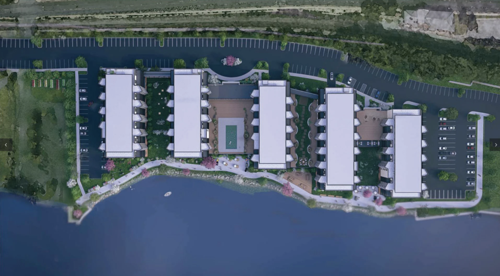
Image from the developer’s own website.
There is a further dimension to the proposal’s site logic that has not yet been named. The Hudson at Newburgh is tidal water. The bed of the river up to the mean high-water mark is owned by the State of New York and held in trust for the public under a doctrine that long predates the city and substantially predates the country. A private waterfront landowner has rights of access and reasonable use, but those rights run alongside, and are subordinate to, the public’s right of access to and use of the water and its shore. The doctrine does not vanish because a developer has assembled a parcel. It does not yield because a site plan has been drawn. It constrains what can be done at the edge regardless of what the deed says, and it constrains it permanently.
The thin walkway in the rendering is the developer’s offered compliance with this constraint. Whether it is adequate compliance — whether a footpath of that depth, without civic programming, without connection to the city’s street grid, with the buildings turned away from it and toward their interior courts, satisfies the public’s interest in the public trust resource it borders — is a legal question that the planning board, the zoning board, and the state agencies with jurisdiction over the river edge are required to answer. The proposal optimizes for private view-amenity by minimizing the depth and function of the public’s interest in the waterfront. The public’s interest in the waterfront is not the developer’s to minimize.
The sightline analysis identified the developer’s organizing principle. The riparian doctrine identifies what that principle is being asserted against. The river edge is not the developer’s to allocate. It is held in trust, on behalf of the public, by the state — and the proposal’s site plan optimizes for private view precisely by reducing the depth and function of the trust resource it is required to respect.
The form gives its back to the city.
The five masses face the river; their balconies, terraces, amenity decks, and primary glazing all face the Hudson; their inland sides face the parking field, the railroad tracks, and Newburgh behind the tracks. The renderings make the orientation explicit. From the river side, the development reads as a freestanding luxury complex on its own private peninsula, with the city of Newburgh barely visible in any image. The historic East End, the Liberty Street corridor, Washington’s Headquarters one block uphill, the brewery district, Broadway — none of it appears in the developer’s renderings. The form has decided that the city is the back-of-house, and the renderings have removed the back-of-house from view. The riverwalk image goes a step further. The path is shown at apparent grade with the building entries, with a strip of lawn between path and platform face that appears continuous. In fact the path is at the river’s edge and the building entries are on a podium raised seven feet above flood elevation; the entries cannot be at grade with the path because the entire structure is engineered to lift the habitable level above the floodplain. The image suppresses the elevation differential by placing the camera where the eye cannot tell. The platform is hidden from view in the rendering whose job is to show the public benefit. And throughout every image — the entry arch, the riverwalk, the aerials — the renderer has scattered cherry blossoms in full bloom. Cherry blossoms are not native to the Hudson Valley waterfront ecology, and the planting plan submitted to the Conservation Advisory Council does not specify them in the bioretention zones, in the riverwalk shrub massing, or in any other planted area.9 The cherry blossoms are atmospheric devices the developer has rendered into every public-facing image to evoke a Tokyo-pastoral mood the project does not commit to delivering. The renderings are advertising. The planting plan is the document of record. The supporter letters’ affection for the project is rhetorical; the developer’s affection for Newburgh is the same. What the form actually loves is the river view from the platform. What it tolerates is the city behind the parking lot.
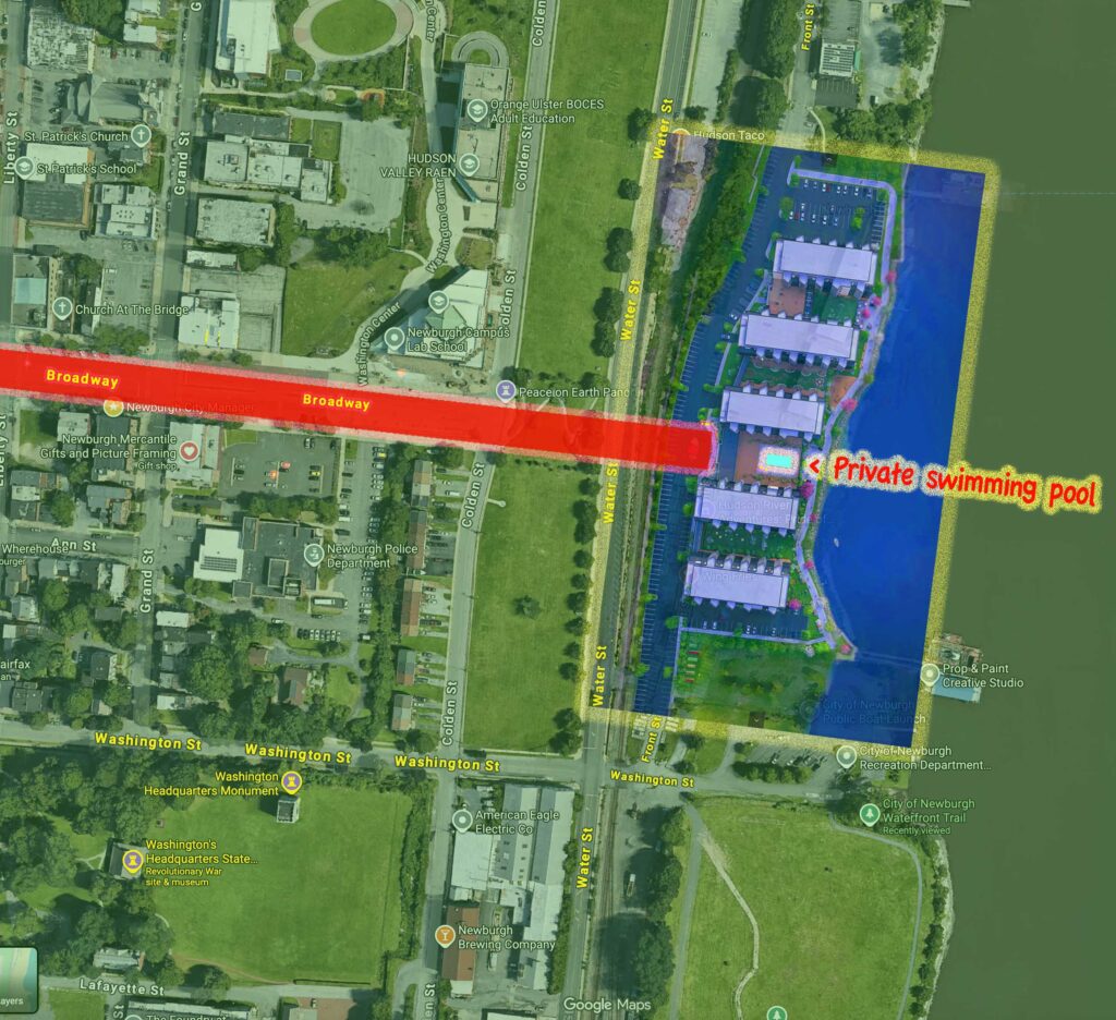
Furthermore, the site is positioned on the terminus of Broadway, the city’s primary civic axis from the historic district to the river. The view from Broadway, looking down toward the Hudson, lands directly on the development’s central courtyard. The first thing the public sees, looking from the city toward the water along the city’s most prominent street, is the swimming pool the development has reserved for its residents. The amenity that organizes the public view is the amenity the public is not permitted to use. The development has positioned its most exclusive feature on the axis of greatest public visibility — not to conceal what it is keeping for itself, but to proudly display it. The pool is the development’s billboard. The riverwalk is the perimeter the public is permitted to occupy. The framework’s distribution of public benefit and private amenity is inverted from the marketing language: the public’s view is filled with what the public cannot have.
This is not 5 residential structures on a waterfront. It is one fortification, elevated to heights from which it can look down at the immediately surrounding city, and give its back to the rest — to a city the developers purport to love. The civic polity has been situated, in spatial terms, around a private enclave whose central feature faces the public realm and excludes the public from it.
I suspect that the developer is at least mildly cognizant of this problem. The evidence is the address itself: 2 Washington Street.
There was no 2 Washington Street as an address until the assessor created one in February. The address does not match the parcel’s actual frontage. The site fronts on Water Street; the southern edge of the parcel is north of where Washington Street ends at the bluff. The administrative entity is the assessor’s invention, and the address is misdirection: Washington Street carries the weight of the city’s revolutionary war history, the proximity to Washington’s Headquarters, the prestige of the founding-era register. The parcel does not sit on that street. The parcel sits on cleared waterfront, behind the railroad tracks, fronting Water Street — a street that also seems to earn the developer’s disrespect; their plans turn most of its frontage into a parking lot. Given the proximity of that parking to the development itself, and the habits of today’s consumers, there will be little room left for the “public” the developer claims is being served. The land beneath the entity is six decades of held ground.
Form follows function: explicitly and implicitly.
The form is justified, when it is justified, by reference to the floodplain. The site sits in FEMA Zone AE at base flood elevation seven feet, with substantial portions of the existing ground below that elevation.10 Habitable space cannot be placed below base flood elevation under federal flood insurance requirements and the City of Newburgh’s own §175 flood damage prevention code.11 The platform, the developer’s engineers will say, is what the flood framework permits to be built here. Parking is the canonical “flood-resistant use” in FEMA-compliant design. The garage holds the lowest floor, the platform raises the habitable program above seven feet, the form is what the regulation produces.
This is true as a description of one possible response to a Zone AE site. It is not true as a description of the response. There is another way to build on a Hudson floodplain, and it has been operating forty miles south of Newburgh for forty-five years.
I attended The Cooper Union from 1972 to 1976. While I was there, I watched — and studied — two of the most consequential floodplain projects of the twentieth century go up on the Hudson. The World Trade Center required the excavation of a seven-story hole — the bathtub, held against the river by a slurry wall — down to bedrock. The fill that came out of that hole was barged north. Battery Park City is where they put the earth.12 The site was raised above flood elevation by importing material — most of it from the Trade Center excavation, the rest from Hudson dredging — to create a new ground at the elevation the floodplain required. The buildings of Battery Park City stand on land. The streets are streets. The esplanade is continuous civic ground that connects to the city behind it. The flood compliance was achieved by changing the elevation of the ground itself.
The proposal at the Newburgh waterfront refuses this solution. Instead of raising the ground, it takes leave of the ground’s existing elevation — much of it below the seven feet, some of it below sea level at the river edge13 — and lifts the habitable program onto a structural podium with parking underneath. The podium is not earth. It is a deck on columns. The civic level of the site, where ground would be in a Battery Park City solution, cannot be a street, because the street would flood. It cannot be a plaza, because the plaza would flood. It cannot be a building entrance, because the entrance would flood. It can only be the parking that FEMA permits below base flood elevation.
The form — this form — is not what the flood framework requires. This form is what the flood framework produces when the developer declines to make ground, and to be grounded — both literally, and historically. Battery Park City made ground. The Newburgh proposal forfeits ground. The technology to do this correctly has existed in New York State, on the Hudson River, for forty-five years. The framework requires only that habitable space sit above flood elevation. How that elevation is achieved — by meeting the land by raising it, or by floating a deck — is the developer’s election, and the developer has elected the form that abandons the ground. What you end up with, which can only be an implicit intention, is a fortified community, severed from its surroundings.
The earth this castle is being built over is not ordinary ground.
The site is approximately ten acres of cleared waterfront on the west bank of the Hudson, between the Newburgh boat launch and the former ferry slip. It is part of a larger contiguous expanse of cleared ground that runs along the waterfront for dozens of acres, all of it produced by a single federal action between 1964 and 1972: the City of Newburgh urban renewal program, designated NY R-37, executed by the Newburgh Urban Renewal Agency under Title I of the Housing Act of 1949 with federal financing and federal oversight.14 The program demolished the East End — the neighborhood that stood on this ground from the early nineteenth century through the demolition years — and displaced the families who had lived there. Those families were disproportionately Black; many were tenants in buildings owned by small landlords, who were also displaced; some were homeowners. They held the ground in the only way ground gets held in an actual neighborhood: by living on it.
The instruments by which they were dispossessed were blight designation and eminent domain. The city used the existing legal authority of New York municipalities to take private property for public use, with just compensation as defined by the urban renewal program’s appraisal protocols, in service of a public purpose the program had defined as redevelopment.15 The instrument required no innovation. It was the ordinary instrument, applied to ordinary holdings, against ordinary holders. What it required was a decision to use it. The city made that decision. The federal program funded the taking. The neighborhood was demolished. The ground was held against return.
What the framework cleared was not just buildings. It cleared the grid. The East End in 1965 was a working urban neighborhood organized into small blocks by a network of streets — Front Street, First Street, Water Street, Liberty Street, Lake Street — that ran from the bluff down to the river. The streets divided the ground into lots; the lots held buildings; the buildings faced the streets; the streets carried civic life. The urban renewal program did not just demolish the buildings on those lots. It demolished the streets between them. When the program ended, the East End was not a vacant neighborhood. It was a vacant superblock — a single undifferentiated expanse of cleared ground where a network of streets and lots had been. The grid had been erased.
This is what made the present proposal possible. Ten acres of contiguous undifferentiated ground is two to three Manhattan blocks. It is larger than any block in the densest American urban grid. A working city would never produce a parcel of this size in walking distance of its historic district, because a working city is organized by streets that divide ground into building-scale lots. The cleared superblock is the precondition for the form. A 172-unit gated compound on a podium with a 470-space parking field cannot be built on a one-acre lot inside a working grid; the lot is too small, the grid forces civic engagement at every edge. The form requires the cleared ground. The framework cleared the ground specifically — though not consciously — to produce the conditions under which a form like this becomes possible. The same logic produced Hudson Yards on twenty-eight acres of former railyards in Manhattan, where the grid had likewise been bypassed by infrastructure rather than destroyed by demolition. The two projects are typologically identical because their preconditions are identical. The ground is what determines the form. The grid-erasure is what determines the ground.
Up the bluff from the cleared ground, the original grid survives. Liberty Street, Lander Street, Chambers Street still run as they did in 1965. The buildings on those streets are nineteenth-century brick rowhouses and frame houses, restored by their current owners over the past two decades, contributing to a National Register Historic District that continues to function as a neighborhood. The grid is intact. The form follows the grid. The civic life follows the form.
The land — cleared not just of buildings, but of the grid that shapes social life — allows ahistorical imagining, the kind that makes ahistorical projects like 2 Washington possible. The vision for this project does not arrive into a state of nature. The land has been held this way — whether by policy or by economics — by intent, for six decades and counting.
The redevelopment that was supposed to follow the clearance immediately after urban renewal — the new tax base, the regional cultural center, the modernized waterfront commercial district — did not arrive. The federal money for clearance ran out before the federal money for rebuilding arrived. The cleared ground sat. Some of it was paved for parking. Some of it was leased or sold to waterfront restaurants. Most of it was held empty, mowed regularly, occupied by surface lots and chain-link, accumulating nothing except time.
A research finding I have developed across the two earlier essays in another series I am writing, summarized here: among the 430 American cities that received federal urban renewal funds between 1949 and 1974, the cities governed under the council-manager form — the form Newburgh adopted in 1916 and operates under today16 — displaced families at approximately fifty percent higher rates than cities governed under the mayor-council form.17 Council-manager cities accumulated larger cleared inventories per capita than their strong-mayor counterparts. They held what they cleared longer. The combination — clear at higher rates, redevelop at lower rates — produced the stockpile of cleared ground that defines the council-manager urban renewal pattern. Newburgh sits inside that pattern. The dozens of acres of cleared waterfront are not an aberration. They are what this form of government produces when it is given access to federal demolition financing and asked to administer afterward.
What the framework calls “vacant” is what the framework calls ground it emptied and refused to repopulate on terms that would have honored the people it removed. The vacancy is not a state of nature. The vacancy is history. The waterfront has been held empty in the same way a hand is held closed. What can a palmreader read if the fist hides the readings that reside in the palm?
The land is now privately owned. The city does not hold it. A private development entity — Riverside Newburgh Realty, LLC, formed to hold this parcel and submit this application18 — holds title to the consolidated lot. The lot itself was created on February 26, 2026, when four separate parcels were merged into a single ten-acre parcel and assigned a new tax map identifier and a new street address: 2 Washington Street.19 There was no 2 Washington Street as an address until the assessor created one in February. The administrative entity is the assessor’s invention. The land beneath the entity is six decades of held ground.
The application is now under review at the Planning Board, the Zoning Board of Appeals, the Conservation Advisory Council, the Technical Advisory Committee, NYSDOT, NYSDEC, the Brownfield Cleanup Program, the State Historic Preservation Office, the Orange County Department of Health, the Floodplain Development Permit administrator, and the SWPPP General Permit reviewer.20 Thirteen parallel proceedings, each evaluating its own slice. None of them is positioned to evaluate the project as a whole. The framework reviews the project in pieces, by bodies whose narrow scopes ensure that the master question — should this be built here — never has to be asked by any one of them.
The application file convicts itself in its own register. The Conservation Advisory Council’s letter of March 2, 2026 does not approve the project; it issues a consistency finding under the Local Waterfront Revitalization Program — the threshold determination required to advance the application — and then lists unresolved concerns the Planning Board is asked to take up.21 The developer’s response letter, ten days later, describes the CAC as having “approved” the project.22 The compression strips out everything the CAC actually flagged: the riverwalk’s ADA compliance, kayak transport capacity, lighting impacts, shoreline planting, riprap consultation with DEC. None of these are committed in the site plan. The developer’s “willingness” to consider them is recorded as if it were a commitment.
The financial structure rests on a PILOT — a payment in lieu of taxes — that does not appear in the developer’s submission to the Planning Board, but appears in two of the supporter letters circulated to the Board. The Orange County Chamber of Commerce letter from April 10 cites the project’s projected $500,000 in annual property tax revenue “even accounting for a limited PILOT on the office portion.”23 A local attorney’s letter of April 21 confirms: “the applicants will only be seeking a PILOT agreement for the commercial portion of the property.”24 The 25,000 square feet of Class A office space — the highest-value commercial component, the part that justifies the parking field — is to receive property tax abatement. The duration, the discount rate, and the post-abatement obligation are not stated. The $500,000 figure being marketed publicly is the figure after the abatement. The pre-abatement figure has not been disclosed.
The office tenant being recruited to take the commercial space is described, identically, across four supporter letters: “approximately 100 high-paying jobs” from “four Hudson Valley offices” being consolidated, with employees earning “more than $100,000 annually.”25 The firm is not named. The lease terms are not stated. The duration of its commitment is not stated. The most economically consequential element of the project — the one that justifies the PILOT, the parking, and the office component’s existence — exists in the public record only as an anonymous stipulation circulated through letters of support.
The public record contains three different descriptions of the same tenant. The supporter letters circulated to the Planning Board describe a financial services firm. Mayor Torrance Harvey, briefing reporters in March, called it an unnamed accounting firm.26 The developer’s own community FAQ, distributed in April, calls it a national financial services firm that plans to consolidate four Hudson Valley offices into one centralized location in the City of Newburgh.27 The three descriptions name different categories of firm — accounting, financial services, national financial services — and the firm itself remains unnamed in every public document. What is consistent across all three descriptions is the consolidation pattern: an existing regional or national presence with multiple offices in the Hudson Valley, being consolidated into a single Newburgh location. Whatever the firm turns out to be, the structural question is the same. PILOTs in New York are administered by Industrial Development Agencies under the statutory purpose of attracting, retaining, and expanding business activity. The Newburgh Industrial Development Agency is the body that would grant the abatement here. The IDA’s statutory but-for test — would the relocation happen without the abatement? — is the question the public record raises on the disclosed facts.28 If the tenant is consolidating an existing Hudson Valley footprint into Newburgh, the PILOT is not paying for new economic activity arriving in the region. It is paying for an existing regional employer to change its address. On a regional consolidation by a firm with a Hudson Valley presence already, the but-for test is difficult to satisfy.
The variances the project requires from the Planned Waterfront District zoning code are not specified in the developer’s application. The Full Environmental Assessment Form acknowledges that ZBA variances are required and lists them only as “ZBA Variances,” without further description.29 A supporter letter calls the variances “de minimis” and asserts that the project “substantively complies with the intended zoning for that area.”30 The letter does not say which variances are being requested or from what provisions. A resident’s opposition letter, citing the PWD code, identifies a possible answer: the code prohibits any building “having a mass of more than 100” feet south of Broadway, and the proposal — though rendered as five separate masses — is in fact one massive connected building.31 If her reading of the provision is correct, the project is in nonconformance on its face, and the “de minimis” framing is doing significant work to obscure what is being requested.
The item was scheduled for public comment at the April 28 hearing of the Zoning Board. The item was removed from the agenda at the last minute.32 Public comment I prepared for the hearing, excerpted from this essay, was therefore not delivered.
This is what the framework operation looks like in present-tense Newburgh. Not malice. Not conspiracy. A staged process in which review is divided across so many bodies that none can ask the master question, financial structures are disclosed in places where they cannot be cross-examined, the most consequential commitments exist in unsigned form, the code violations are pre-emptively reframed as routine variances, and the public hearing scheduled for the public to speak is canceled when the public arrives prepared. Each move is procedurally regular. The accumulation is what the framework is.
Options. A Choice.
This is the third piece in a series. The first, “We Know Who You Are Working For,” examined how the City of Newburgh accumulates property through quiet administrative default — small holders losing property to the city through tax delinquency, mortgage foreclosure, and code enforcement actions, with the city’s authority deployed aggressively against holders too small to defend themselves. The second, “Reparations: ‘The Preferential Rental Option for the Displaced,'” examined the Kearney proposal — affordable rentals on urban renewal ground, with displaced families at the front of the line — and argued that rental tenancy is not reparations. Reparations requires equity, not subsidized tenancy on the same ground from which equity was taken.33
A reliable source told me that the developers said at a zoning board meeting that if the city does not give them what they want, that they will withdraw the application and go elsewhere. He told me that corporation counsel warned the board that the owners could sue.
The developer’s threat is the framework’s standard opening move when conditioning is on the table. The threat works when the city’s procedural posture does not contemplate the answer it invites: yes, withdraw, take your application elsewhere, and the city will retain control of what gets built on this ground. Corporation counsel could have represented the city and carried that answer into the room. Corporation counsel could tell the developers that they should take better care of what they ask for. Instead, corporation counsel carried the developer’s litigation warning. The legal officer’s choice of which direction to carry leverage is itself a structural disclosure.
In 1968 the city of Newburgh used blight designation and eminent domain to take this ground. The instruments were the ordinary instruments: New York’s General Municipal Law authority to declare urban renewal areas and to condemn private property for public use, with just compensation, in service of a public purpose the program had defined as redevelopment. The city decided to use them. The federal program funded the taking. The neighborhood was demolished. The action served private interests camouflaged as public good (the federal program’s promise that cleared ground would attract investment), the structural interest in remaking the waterfront for uses and populations other than the ones already there proceeded.
The same instruments exist in 2026. They have not been weakened. New York municipalities retain the same authority to declare blight and to take private property for public use, on the same legal basis, that they exercised sixty years ago.34 What is different is not the instruments. What is different is what the city is willing to use them for, and the class of people they are directed to.
The cleared ground produced by the 1968 action can be conditioned by the same instruments now — on behalf of the people the action displaced. The city can declare the present holding a blighted area, seize it with just compensation to the current developer/owners, and convey it to a community land trust that holds the ground in perpetuity for the benefit of Newburgh residents, particularly those whose families were displaced from this ground in 1968. Short of that, the city can condition any private redevelopment on a CLT conveyance covering a substantial portion of the parcel, on affordable housing requirements substantial enough to constitute return rather than tokenism, on civic ground at grade rather than on parking at grade.
That is what the city could do.
The choice is not abstract. The families displaced in 1968 are aging out of the population that could be returned. Their descendants may soon be watching a market-rate gated community rising on the ground their grandparents lived on. Every year the city declines to act, the people the action is owed to are fewer, and the framework’s wait gets shorter. Is there no city official empowered to officially apologize for 1968? Is it because the city has never decided that 1968 requires an official apology? The conditioning instruments are not being used because the people who would direct their use have not yet decided that they need to actually act on what they owe.
The Insult
If a market-rate gated community on cleared urban renewal ground, disconnected by design from the surrounding city and its history of dislocation and trauma is not an insult to so many of the people of this city, I am hard pressed to figure out what would constitute one.
As an ethical and philosophical matter, this proposal should be dismissed out of hand.
2 Washington Street: a gated community that turns its back on the city, built on sacred urban renewal ground, a platform marked with five apartment slabs that are tombstone-like in appearance (to put not too fine a point on it), tie it up with a twelve-foot wide ribbon along the river and call it The People’s Pedestrian Plaza. Hey, what’s not to like?
Given the rich architectural legacy of this city, a lot.
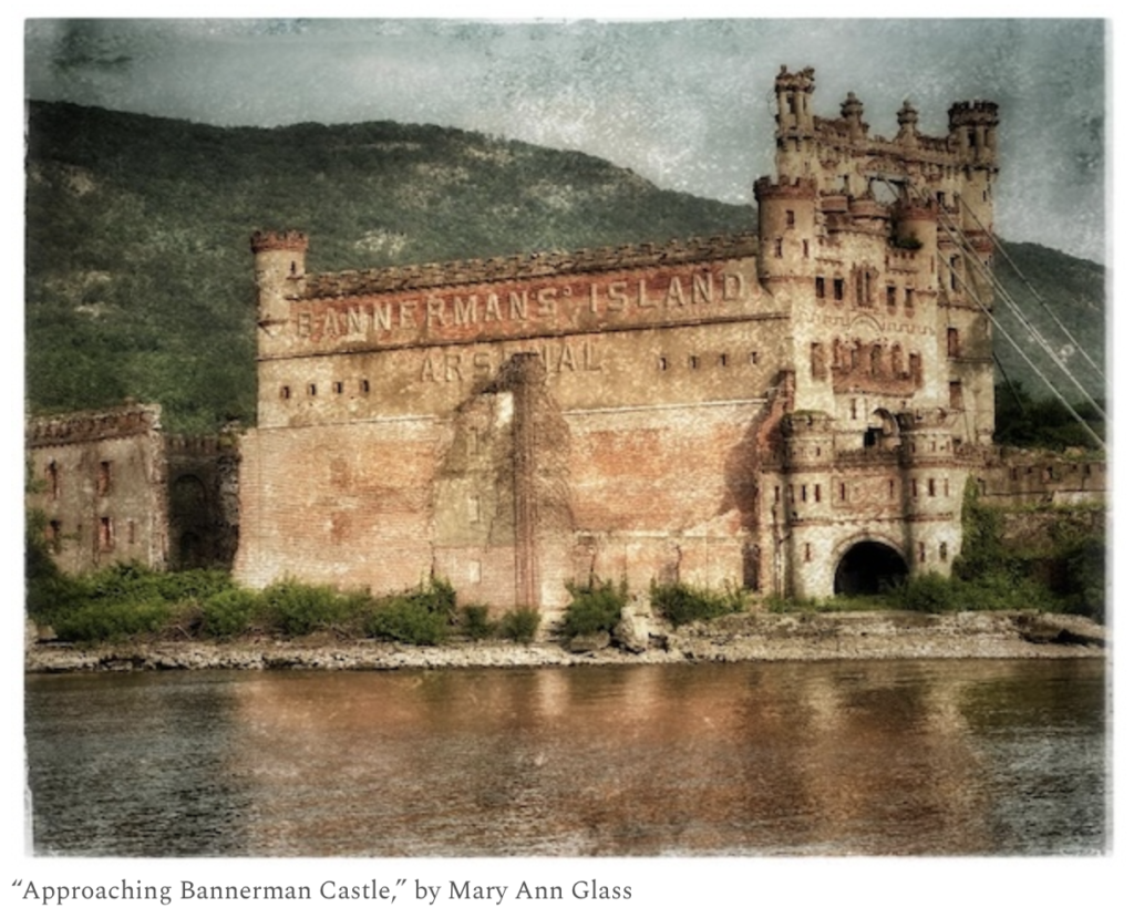
I mean, really: I have been arguing throughout that this is a 21st century version of a 14th century fortified castle, marketed to the aspirational class as a refuge from the city it sits upon … a city the developers claim to love.
But don’t we already have a castle, within sight, right down the river: Bannerman Castle? It is patiently waiting for restoration itself. If an hermetically-sealed castle is really what Newburgh wants, the developer has two options. One: put the Bannerman on a barge, tow it upriver, and plop it down at 2 Washington. Get gated community housing and office space while engaging in a significant restoration project, all in one fell swoop. It is certainly fortress like, and the fact that it was once a munitions depot is probably not incidental to the symbolism. Two: buy Bannerman island, tear down the castle, and put this modern version in its place. The ferry people will be pleased, with one small caveat: the ferry will need to be revived, but it will bypass Newburgh on its route from Beacon to Bannerman.
In Closing
If the developer/owners feel insulted by what I have said here, they should try to understand that my only crimes are the ability to read the plain language of their architect’s own drawings, and the willingness to say out loud what my eyes are reading.
This plan irrevocably, irreversibly changes the civic character of this city, and its narrative about itself. It is the change of the city’s spatial relationship to its own history. Newburgh’s civic character has been organized for two and a half centuries around the Broadway axis running from the historic uphill neighborhoods down to the river — a sight line that has carried the democratic conversation of the early Republic in physical form. Washington’s Headquarters sits within that organization. The grid of Liberty Street, Lander Street, Chambers Street sits within it. The view down Broadway to the Hudson has been part of how the city tells itself what it is.
The development positions itself at the terminus of that axis and reorients the view from the city’s primary civic spine onto a private swimming pool. That is not a building going up on a parcel. That is the city’s most important sight line being commandeered, in perpetuity, by a private amenity that the public is excluded from. Once it is built, every future resident of Newburgh who walks down Broadway will be walking toward a private gate. Every future visitor coming to Washington’s Headquarters will be looking, from the bluff, at a fortified compound on the cleared ground below. The civic axis the city has organized itself around for centuries will, for the rest of the city’s existence, terminate on a thing the public cannot enter. The city will have lost something it cannot recover by political action, by future zoning, by future design competitions, by anything short of taking the parcel back and starting over. The framework’s pattern has been to defer that recovery indefinitely. The development gets built; the deferral becomes permanent.
Will this city retain the capacity to decide what its civic character is?
The answer to that question depends in large part on whether the city’s reviewing bodies — the planning board, the zoning board of appeals, the city council — simply applies the standards already on the books.
The proposal is reviewed against standards Newburgh has already adopted. The Planned Waterfront District code (Chapter 300, Article XV) requires public access of specific dimensions: a waterfront area open to the public with a minimum width of twenty feet measured perpendicular from the shoreline, within which a publicly accessible walkway of at least twelve feet must be provided. The developer’s offered “twelve-foot strip of public access along the water” is the minimum width of the walkway, not the minimum width of the waterfront area the walkway is required to sit within. On the face of the application, the proposal does not meet the public-access dimensional standard the code requires.
The same code requires that waterfront access “be accessible from a public sidewalk, street, public park, or other public place,” with such access “no less often than every 400 feet from a public place,” and that the development “connect to the waterfront walkways on adjacent lots.” The site plan, as rendered, does not show such connections. The five-mass complex sits on a continuous podium that severs rather than extends the city’s street grid to the river.
The code expressly prohibits construction within the rights-of-way of Washington Street, Second Street, Third Street, Fourth Street, and South Street, “from the easternmost terminus of the following streets to the Hudson River shoreline.” The City Charter goes further: it forever vests “all estate, title and interest to all such lands under water of the river in front of said streets… in the City for the use and purpose of public streets and highways forever.” The development is named for the street whose extension to the river the Charter declares to be perpetually public. Whether the proposal honors that perpetual public interest in the Washington Street right-of-way is a question the boards are required to answer on the record.
The code requires that all site plan applications be evaluated for impacts on seven enumerated scenic views, including the view from “Broadway and Colden Street.” The civic axis terminating on a private swimming pool is exactly the impact the code requires the planning board to evaluate. The Local Waterfront Revitalization Program, adopted in 2001 and approved by the State and federal governments, identifies as a planning issue that “the Lower Broadway corridor needs to be connected with the waterfront area.” The standards are not vague. The standards are explicit, dimensional, and tied to specific streets, specific viewsheds, and specific public access requirements. Whether the proposal complies with them is the question. The record on this proposal, as filed, indicates it does not.
Under the State Environmental Quality Review Act (SEQRA), the lead agency is required to take a hard look at the proposal’s impact on community character, public access, and consistency with the city’s adopted plans, and to address those impacts on the record before approval. The analysis presented in this piece identifies impacts the agency cannot lawfully approve without addressing. A denial resolution finding that the proposal optimizes for private view-amenity rather than the density, connectivity, and public-edge characteristics required by the comprehensive plan and the LWRP is a finding the record supports. The boards have the standards. The standards are clear. Whether they are applied is a separate question.
That separate question is the one the series has been asking from the beginning. The 430-city research established that council-manager cities displaced families at fifty percent higher rates than mayor-council cities during the urban renewal period — that the form’s technocratic insulation translated, structurally, into deference to private capital and to the assumptions of planning-as-clearance. 2 Washington is the contemporary form of the same arrangement. Cleared land. A private developer. A council-manager apparatus structurally disposed to defer. Whether Newburgh’s reviewing bodies can recognize the proposal for what it is and apply the standards already adopted is the test of whether the form has improved in sixty years or whether the form is still doing the work it was designed to do. The waterfront is the site. The decision is the answer.
If this same city hands out PILOTS to the affordable housing industry like Halloween candy, or accepts a return of forty five cents for every dollar from a land bank that demolishes seventy five percent of the buildings it’s chartered to save, is it well-suited to think through a development plan like this?
For now, this is not what democratic-minded planning looks like. It is not civic engagement with the community. It is its direct opposite: it is private interest dressed up with a public bow.
We will talk about what a developer’s civic engagement looks like when we revisit the last time something like that was attempted: the Leyland proposal.
© Newburgh Is America
Notes
I am a one-man band here — writer, editor, copy editor, fact-checker, legal consultant, publisher and moderator wrapped into one, publishing within a time line that is compressed from the weeks or even months of what is normally allowed for long-form investigative writing into sometimes as little as a few days. Errors and omissions are inevitable in work produced under these conditions. I rely on an informed public to identify them, and where they are identified, the record is corrected. This piece reflects my best understanding at the time of publication and is subject to revision as additional information becomes available.
Footnotes
- Riverside Newburgh Realty, LLC, Washington Street Waterfront Redevelopment, application materials submitted to City of Newburgh Planning Board, file PB2026-01, received April 10, 2026, scheduled for Planning Board meeting April 21, 2026. Engineering and Surveying Properties, PC (Montgomery, NY), engineers of record. Architectural rendering circulated with application materials. ↩
- Riverside Newburgh Realty, LLC, Full Environmental Assessment Form, Part 1, Section A and Section D.1, file PB2026-01, April 10, 2026; Engineering and Surveying Properties, PC, Site Plan, Sheet C-103, drawing set for Washington Street Redevelopment, April 10, 2026. Parking counts: 189 enclosed garage spaces plus 281 surface spaces totaling 470, of which 429 are designated parking spaces per EAF Section D.2.j.iii.
- Engineering and Surveying Properties, PC, applicant response letter to City of Newburgh Planning Board, file PB2026-01, April 10, 2026.
- Riverside Newburgh Realty, LLC, Full Environmental Assessment Form, Section A, brief description of proposed action: “residential amenity areas consisting of but not limited to a community garden, dog park, pool, gym & exercise areas, and a riverwalk open to the public along the banks of the Hudson River.”
- Engineering and Surveying Properties, PC, Site Plan, Sheet C-103, April 10, 2026, indicating “12′ WIDE RIVERWALK” along the Hudson River shoreline.
- Engineering and Surveying Properties, PC, Landscape Plan, drawing set for Washington Street Redevelopment, file PB2026-01, April 10, 2026. Plant palette for Area 1 and Area 2 (riverwalk) includes boxwood, skip laurel, Lenten rose, bayberry, and coastal doghobble.
- Architectural renderings circulated by the developer for the Washington Street Redevelopment, including entry-arch elevation, riverwalk vignette, and aerial views, file PB2026-01.
- Bonura Hospitality Group, Residences at West Hills Country Club, Middletown, NY, marketed on the developer’s website at bonurahospitality.com as “a luxurious apartment building boasting 158 spacious units with elegant finishes and private balconies offering stunning views of the Wallkill River and Championship Golf Course.”
- Engineering and Surveying Properties, PC, Landscape Plan, file PB2026-01, April 10, 2026. The plant palette specified for the bioretention ponds, Amenity Decks 1 and 2, and the riverwalk (Areas 1 and 2) does not include any Prunus serrulata (Japanese flowering cherry), Prunus × yedoensis (Yoshino cherry), or other ornamental cherry species. The flowering trees rendered throughout the developer’s marketing images are not specified in the document of record.
- Engineering and Surveying Properties, PC, Survey, Sheet S-1 Rev 3, file PB2026-01; Stormwater Pollution Prevention Plan (SWPPP), file PB2026-01, April 10, 2026, identifying the entire site as FEMA Zone AE at base flood elevation 7.0 feet (NAVD 1988).
- City of Newburgh Code, Chapter 175, Flood Damage Prevention; National Flood Insurance Program regulations, 44 CFR § 60.3.
- Battery Park City was authorized by New York State legislation in 1968 (the Battery Park City Authority Act, NY Pub. Auth. Law §§ 1971–1985) and constructed beginning in 1969, with landfill operations using material excavated from the World Trade Center site (1968–1972) and additional Hudson River dredging. See Battery Park City Authority, public history materials, bpca.ny.gov.
- Engineering and Surveying Properties, PC, Survey, Sheet S-1 Rev 3, indicating existing topography ranging from approximately +32 feet to approximately −12 feet at the river edge.
- City of Newburgh urban renewal program, federal designation NY R-37, administered by the Newburgh Urban Renewal Agency under Title I of the Housing Act of 1949, with federal financing through the U.S. Department of Housing and Urban Development. Program records are held in the City of Newburgh archives and in the federal urban renewal records at the National Archives, Record Group 207. See also published histories of Newburgh urban renewal including Richard Plunz, A History of Housing in New York City (Columbia University Press), and contemporary news coverage in the Newburgh News and Times Herald-Record, 1965–1972.
- Eminent domain authority for New York municipal urban renewal projects derives from New York General Municipal Law Article 15 (Urban Renewal), §§ 500–525, as it stood during the program period, in conjunction with federal authorization under the Housing Act of 1949 (Pub. L. 81-171).
- City of Newburgh Charter, adopted 1916, establishing the council-manager form of government. See “We Know Who You Are Working For” for fuller treatment of the council-manager form as it operates in Newburgh.
- Original research by this writer, drawn from a matched dataset of 430 American cities receiving federal urban renewal funds between 1949 and 1974 (215 council-manager and 215 mayor-council cities, covering 95.7% of all federally recorded displaced families). Forthcoming in this series; preliminary findings shared with Dr. Robert Nelson, University of Richmond Digital Scholarship Lab, and Dr. David Hochfelder, University at Albany.
- Riverside Newburgh Realty, LLC, c/o Joe Bonura, 2975 Route 9W, New Windsor, NY 12553, listed as applicant/sponsor and property owner in the Full Environmental Assessment Form, Section A.
- Email from Edmund Lupinski, Assistant Assessor, City of Newburgh, confirming lot consolidation effective February 26, 2026, file PB2026-01. The four parcels formerly identified as SBL 37-4-2.1, 37-4-2.2, 37-4-3.1, and 37-4-4 were merged into a single parcel SBL 37-4-3.2, assigned the address 2 Washington Street.
- Full Environmental Assessment Form, Sections B.b through B.h and Section D.2.h, listing required approvals; Floodplain Development Permit Application, City of Newburgh, file PB2026-01; SWPPP, file PB2026-01, April 10, 2026.
- City of Newburgh Conservation Advisory Council, letter to Planning Board regarding Washington Street Redevelopment, dated for the March 2, 2026 CAC meeting, file PB2026-01.
- Engineering and Surveying Properties, PC, applicant response letter, April 10, 2026, file PB2026-01: “the project was in front of the Conservation Advisory Council on March 2nd and was approved.”
- Heather Bell, CEO and President, Orange County Chamber of Commerce, letter of support to City of Newburgh Planning Board re: 2 Washington Street Residential Development, April 10, 2026, file PB2026-01.
- Austin DuBois, letter to City of Newburgh Planning Board and Zoning Board of Appeals re: Letter in Support of 2 Washington St., emailed April 21, 2026.
- Statement consistent across four letters of support filed in PB2026-01: Orange County Chamber of Commerce (Bell), April 10, 2026; County Executive Steven M. Neuhaus, March 31, 2026; Sheryl Ranke (Captain Jake’s), April 8, 2026; Austin DuBois, April 21, 2026.
- Hank Gross, “Local developers have plans for former ferry parking lot,” Mid Hudson News, March 30, 2026, midhudsonnews.com. Mayor Torrance Harvey is quoted describing the prospective office tenant as “an unnamed accounting firm.” The article also identifies the developer as a joint venture between The Kaplan Family and the Bonura Group.
- Bonura/Kaplan joint venture, 2 Washington: A New Chapter for Newburgh’s Waterfront, community FAQ document, distributed April 2026.
- New York General Municipal Law Article 18-A (Industrial Development Agencies), §§ 850–890. The “but for” analysis is a standard component of IDA cost-benefit review: the agency must determine that the public benefits of the project would not occur without the requested financial assistance. See also New York State Authorities Budget Office, Annual Reports on IDA Performance, abo.ny.gov, for compliance reporting on this analysis.
- Full Environmental Assessment Form, Section B.c, identifying “ZBA Variances” as required without further specification.
- Austin DuBois, letter of April 21, 2026, file PB2026-01.
- Almas (Ally) Merchant, PhD, Ward 1 resident, public comment email to Planning Board, April 21, 2026, file PB2026-01, citing the Planned Waterfront District provision of the City of Newburgh Zoning Code, Chapter 300. The exact code section and provision should be verified against the current code.
- City of Newburgh Zoning Board of Appeals, agenda for meeting of April 28, 2026, as scheduled and as conducted; the Washington Street Redevelopment item (file PB2026-01) was removed from the agenda prior to the meeting.
- See “We Know Who You Are Working For” and “Reparations: ‘The Preferential Rental Option for the Displaced,'” published at Newburgh Is America, newburghisamerica.com.
- U.S. Constitution, Fifth Amendment; New York State Constitution, Article I, § 7; New York Eminent Domain Procedure Law (EDPL); New York General Municipal Law Article 15 (Urban Renewal), authorizing municipal blight designation and condemnation. The legal authority of a New York municipality to declare urban renewal areas and to acquire private property for public use, with just compensation, has not been materially weakened in the period 1968–2026.